
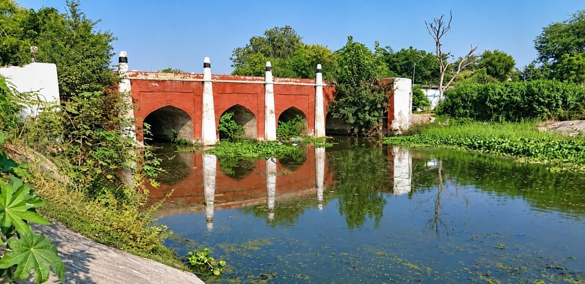
Northwest of Sirhind in Punjab, a watercourse passes beneath an old Mughal bridge between two historic gurdwaras that commemorate the martyrdom of the younger Sahibzadas and preserve the memory of Mata Gujri Ji. Local residents call it the Hansla River. The Government of India’s Virtual Museum of Images and Sounds and archival sources describe the bridge as spanning the seasonal Sirhind Choe. The museum documents its arches and masonry and dates it to the Mughal period, but does not name the watercourse as Hansla. The difference in names reflects distinct local and administrative records; it does not, by itself, establish a change in the channel’s course.
Some media accounts connect the relocation of the Grand Trunk Road with the channel’s transformation into a drain called the Sirhind Choe. Archival references, however, describe a seasonal channel beneath the bridge. The reported connection is a useful lead, but a dated map or engineering record is needed to establish when the route or channel changed. This distinction matters: the present condition is clear, while the physical history of Hansla has not been reconstructed.
Official planning and pollution records place the Sirhind Choe within a seasonal drainage system. The Fatehgarh Sahib-Sirhind Master Plan describes a rainfall-fed source near the town; a Central Pollution Control Board document classifies the channel as non-perennial and traces it from Sirhind to the Ghaggar. Read alongside local use of the name Hansla, these records place the watercourse within the wider basin. They also point to a practical priority: mapping the catchment and documenting seasonal flows alongside urban growth, agricultural use and channel engineering.
Sirhind’s public history is shaped by its Mughal past, its monuments and its profound place in Sikh memory. It recalls the martyrdom of Guru Gobind Singh Ji’s younger Sahibzadas and the rise of Sikh rule under Banda Singh Bahadur, whose rule challenged established agrarian hierarchies and is associated with extending rights to cultivators. Yet the Hansla appears mainly in administrative and environmental records: as a bridge setting, a drainage channel or a site of pollution measurement. Bringing these records together would give the watercourse a more coherent place in the history of the town.
A 2023 Punjab and Haryana High Court judgment offers a precise account of part of the channel’s present form. The State described it as a natural rainwater channel recorded in revenue documents and notified as a drain. The Court noted that a plan approved in 1979 channelised the downstream reach while the upstream section remained natural. It directed authorities to prevent overflow from damaging farmland. The judgment establishes partial channelisation and the channel’s role in local drainage; read with maps and field surveys, it can help guide a fuller reconstruction of its course.
The channel’s natural and engineered sections shape how monsoon runoff moves through agricultural and urban land. Its floodplain, culverts and outfalls affect where water flows and what enters it. Channelisation and desilting can reduce local flood risk, but lasting management also requires attention to land use and water quality. The records do not show that official classification as a drain caused neglect. They do show how responsibility is divided across agencies whose records rarely connect drainage, heritage and environmental health.
Water-quality studies document substantial pollution at particular sites and times. In 2022, Harneet Kaur, Anita Rajor and Amritpal Singh Kaleka sampled the Sirhind Choe as one of three drains in the Ghaggar basin. Across five seasons in 2017–18, the mean biochemical oxygen demand at their Sirhind Choe station was 22.2 milligrams per litre, and mean chemical oxygen demand was 81.6 milligrams per litre. The authors associated pollution in the study area with domestic and agricultural sources. A 2024 study by Kaur, Kaleka and Rajor reported a mean lead concentration of 120 micrograms per litre at its Sirhind Choe site. These measurements make the case for regular, public monitoring. The later study’s health-risk estimates are model-based and should not be read as evidence of diagnosed illness among residents.
Two 2026 records point to different pressures. In January, the National Green Tribunal recorded solid waste beside Hansla Nadi and violations relating to pollution-control consent and procedures. In August, Hindustan Times reported that a Punjab government affidavit acknowledged wastewater and pollutant discharges into the Hansla River. It said two sewage-treatment plants serving Sirhind were being tested and stabilised before full commissioning. Waste dumped beside a channel and wastewater entering it require distinct remedies. Desilting alone addresses neither.
A useful next step is a shared, publicly accessible map of the Hansla and Sirhind Choe, showing natural and channelised reaches, culverts, outfalls, treatment-plant connections and the agencies responsible for them. Seasonal water-quality results from fixed sampling points should accompany it. Historical maps, revenue records and engineering plans can then be compared with field surveys and residents’ accounts of local names and uses. This would connect the channel’s documented present to its changing place in the town.
Hansla is remembered locally as a river, recorded officially as a seasonal choe or drain, and measured in studies of pollution. Each description captures part of its history and present condition. Taken together, the evidence makes a clear case for action: publish the channel map, monitor water quality through the seasons and coordinate the agencies responsible for its care. Reconstructing its earlier course will require historical and field evidence, but uncertainty about the past need not delay work on the pollution visible today. Treating Hansla as both a watercourse and part of Sirhind’s living history is the beginning of that work.



Leave a Reply